|

Home
Alaska
Albuquerque balloons
Antarctica
Astronomical Sites
Chile
Clouds
Egypt
England
Flowers
icebergs
infrared
Monument Valley
Nepal
New England's autumn leaves
New Zealand
Polynesia
scenic treasures
Switzerland
Yosemite in Spring
Yosemite in Winter
Milford Sound and Fjordland National
Park Photo Page
(all photos taken in November, 1980)
Other New Zealand Pages:
New Zealand
Photo Index
North
Island South Island
Slide Show
New Zealand South Island Slide Show
-- from mstecker.com
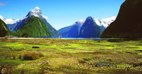
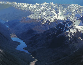
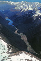
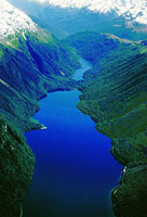
Fjordland National Park, New Zealand's largest national
park -- est. 1952, is located in the southwest portion of the South
Island. It stretches over 124 miles (200 kilometers), from Milford Sound
in the north to Preservation Inlet in the south, and covers 1.25 million
hectares. The Tasman Coast lies on its western boundary, to the east is a
drier lower elevation region defined by large lakes and to the north lies
the Southern Alps. Fjordland's serrated coastline and deep branching lakes
were carved out by glaciers millions of years ago, leaving behind a land
internationally acclaimed for its spectacular scenery, isolation and
uninhabited environment. Fiordland's mountains are highest in the north
reaching 2746 meters (9009 feet) at Mt Tutoko of the Darran Range.
Glaciers flowing from the mountains to the west gouge sounds (fjords) like
Milford, Doubtful and Dusky, while ice flowing to the east and south form
lakes like Te Anau and Manapouri. Glaciation also results in a combination
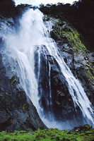
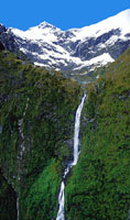
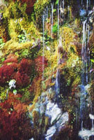
of deep valleys, sheer rock cliffs, hanging waterfalls (e.g. Sutherland
and Stirling) and deep blue lakes. Fiordland has very high precipitation
resulting in glaciers in the mountains and a high average rainfall of
about 250 inches a year at the lower elevations.
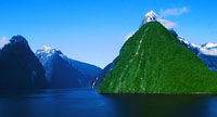
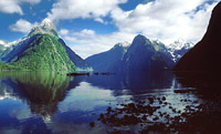
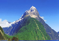
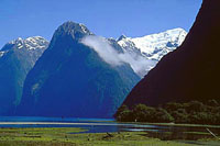
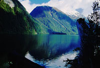
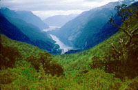
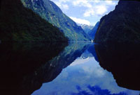
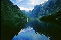
Within Fiordland National Park is Milford Sound, the best known of the
many sounds like Doubtful, Dusky, etc. that indent the coast here. It can
be reached by airplane, car, bus or on foot. The land route (NZ 94) to
Milford Sound is one of the world's finest alpine drives. From Te Anau the
road winds down the Eglinton and Hollyford Valleys then through the Homer
Tunnel to be met by Mitre Peak towering from the glassy waters of Milford
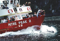
Sound. This Sound is the most famous and accessible of the fiords. Boat
trips on it are a must with close up views of the awesome scenery as well
as sightings of dolphins and seals. The sound or fjord was carved by
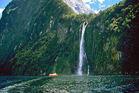
glaciers and then flooded by the Tasman Sea. Average annual rainfall of
more than 7,010 millimeters (276 inches) makes Milford the country's
wettest spot. The Sound measures about 19 kilometers (12 miles) long and 3
kilometers (2 miles) wide. With steep rock walls eroded by glaciers, the
inlet is a scenic tourist attraction. At its entrance, visitors can see
the reflection of Mitre Peak, which rises 1,695 meters (5,561 feet) above
sea level.
|