|
Introduction
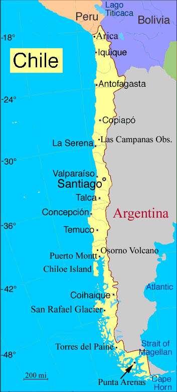
Chile (from the Indian word meaning, "where the land ends")
is a country of startling contrasts and great beauty. This is in large
measure because of its unusual geography. Its north-south length covers
over 30-degrees of latitude or 2,700 miles, a distance roughly the same as
that from San Francisco to New York. Also, its unique location relative to
the oceanic/continental tectonic plates, Humboldt Current and high Andes
mountains result in weather and terrain that varies from the bone dry
Atacama Desert in the north to the wet south -- where forests, lakes,
fjords, volcanoes and glaciers are common place.
Statistics
Name:
Republic of Chile
Location:
West-southern South America; Argentina to the east and
Peru and Bolivia to the north
Area:
total: 756,950 sq km
slightly smaller than twice the size of Montana
Coastline:
6,435 km
Elevation:
lowest point: Pacific Ocean 0 meters
highest point: Cerro Aconcagua 6,962 meters
Natural resources:
copper, timber, iron ore, nitrates, precious metals,
molybdenum
Population:
approximately 15 million
Ethnic groups:
white and white-Amerindian 95%, Amerindian 3%, other 2%
Religions:
Roman Catholic 89%, Protestant 11%, Jewish
Government type:
Republic, democratic
National capital:
Santiago
|
|
Chile's northern neighbors are Peru and
Bolivia, and its eastern border with Argentina (5,150 kilometers), is one
of the world's longest. Off the coast of the northern 2/3 of Chile is one
of the most active of the Pacific tectonic plates -- the Nazca Plate. It
is moving eastward about ten centimeters a year, forcing its way under the
continental plate of South America. This movement has resulted in the
formation of the Peru-Chile Oceanic Trench which is about 150 kilometers
wide and averages 5,000 meters in depth. At its deepest point, just north
of the port of Antofagasta, it plunges to 8,066 meters. Plate
movement also results in many earthquakes and about 620 volcanoes, many of
them active. More than half of Chile's land surface is volcanic in origin.
Much of Chile's coastline is cooled by the frigid Humboldt Current, which
originates northwest of the Antarctic Peninsula, runs the full length of
the Chile and contributes to the climatic conditions of the country. The
country can be roughly divided into three regions: north, central and
south. In all three regions there are narrow depression between the
mountains and the sea. In the north the land rises and becomes more arid,
until one reaches the forbidding Atacama Desert -- the driest desert on
earth. The center of Chile covers a 700 mile corridor called the Central
Valley. In the northern Central Valley are vineyards (like the Elqui
Valley where Pisco brandy is made) and great farms. In its mid-section are
the population centers of Santiago and Valpariso and in its southern
section are primeval forests, enchanting lakes and conical volcanoes.
South of the central region is the southern region where the coastal
climate is wet and the land falls away from the mountains. Here the
valleys between the mountains and ocean fade into a baffling archipelago
of islands and fjords. This region is called Chilean Patagonia. It is
divided into two sub-regions; the northern Aisen and southern Magallanes.
Aisen is home to Parque National Laguna San Rafael,
while Magellanes hosts the incomparable Parque National Torres del Paine.
Near the southern tip of Chile's mainland is
Punta
Arenas, the southernmost city in the world, and beyond that the
Strait of Magellan and Tierra del Fuego. Not far south of here is the
Beagle Channel -- a waterway that is
surrounded by mountains and several glaciers that empty into it. The
glaciers are named after European countries like Italy, Romania, etc. The
channel gets its name from the ship Beagle that carried the naturalist
Charles Darwin to South America. Further south is
Puerto Williams -- said to be the southern most town in the world
at Latitude S 54 deg 56 min. The southernmost point of South America is
Cape Horn which belongs to Chile.
West of the continent are Chile's Easter Island and Juan Fernández
Islands. Easter Island (Isla de Pascua, population 2800) is located in the
center of the Pacific Ocean, 3,700 kilometers from the Chilean coast and
4,000 kilometers from Tahiti. The Dutch explorer Jacob Roggeveen
discovered the island on Easter Sunday, 1722. Chile took possession of the
island in 1888. The native islanders -- Rapa Nui -- call it Te Pito o Te
Henua, "The Navel of the World." It is noted for its 867 Moais, which are
huge (up to twenty meters high) carved volcanic stone statues with
mysterious faces. The Islas Juan Fernández, located 587 kilometers west of
Valparaíso, are the locale of a small fishing settlement. They are famous
for their lobster and the fact that one of the islands, Isla Robinson
Crusoe, is thought to be the inspiration for Daniel Defoe's novel.
Points of Interest
.
Parque Nacional Lauca
In far northern Chile, 100 hundred miles northeast of Arica is Lake
Chungará (17,384 ft -- one of the highest lakes in the world). It is
situated at the foot of the dormant spectacular twin Pallachata volcanoes.
Astronomical Observatories
In northern Chile dry climate, clear skies and great seeing conditions
(steady air) results in one of the premier astronomical locations in the
world. The major observatories of Cerro Tololo (NOAO --one of the USA's
national observatories), Carnegie Las Campanas
Observatory and the European Southern Observatories (ESO) are all
located on mountains west of the Andes in the southern Atacama desert. ESO
is currently building the Very Large Telescope (VLT) further north in the
Atacama. When completed it will be the largest telescope in the world.
La Serena
Important both historically and economically, the beachside city of La
Serena is one of Chile's oldest post-Columbia cities. The region's silver,
copper and agriculture were so important that the city had its own mint.
Today, La Serena is the gateway to the Atacama. It maintains a colonial
air with great beaches. Attractions include a handful of museums and a
number of nearby quaint villages and vineyards.
Viña del Mar
Chile's premier beach resort is only 10km (6mi) north of Valparaíso. It is
popularly known as the Garden City because of its subtropical landscapes
and planned parks. Horse-drawn carriages trot past attractive
turn-of-the-century mansions on both river and beach frontages. Other
attractions are its casino, beaches, parks and museum. The town is also
the home of Chile's national botanical garden, comprising 150 acres of
native and exotic plants.
Parque Nacional Puyehue
Situated in the beautiful Lake District is Chile's most popular national
park. It preserves 264,000 acres of verdant mountain forest, awesome
volcanic scenery and azure lakes. Nature trails, lake views, waterfalls,
thermal springs and ski resorts are some of the many attractions which
draw visitors here every year.
Osorno Volcano
This flawless volcanic cone (north of Puerto Montt) sits in the Parque
Nacional Vicente Pérez Rosales, the first national park in Chile, and is
surrounded by wonderful natural attractions. Beautiful Lago Todos Los
Santos is the centerpiece of the park. Ferry boats transport tourists
through the lake system where beautiful views of lake, forest and volcano
are seen. Osorno is also a popular skiing site.
Puerto Montt
Settled by German colonists in the mid-19th century, it features
middle-European architecture, with high-pitched roofs and ornate
balconies. Puerto Montt is the transport hub and access point to the
southern Lake District, the island of Chiloé and Patagonia. It was my
gateway port to the chilean fjords and Antarctica.
Chiloé Island
The island is about 112 miles long and 31 miles wide. It is a densely
forested island of undulating hills, with a wet and foggy maritime
climate. It features distinctive
stilt homes
(palafitos) along its waterways. When visible, a majestic panorama across
the gulf to the snow-capped volcanoes of the mainland is revealed. Ancud
and Castro are the only two sizeable towns, but there are over 150
picturesque wooden churches servicing the island's small villages.
Parque Nacional Laguna San Rafael
This glacier-filled, 4.2 million acre park in coastal Patagonia is the
most popular attraction in the Aisén region. It is the home of the
San Rafael Glacier, encompassing some of the
most spectacular fjords, mountain scenery and icebergs in Chile.
Parque Nacional Torres del Paine
Is southern Chile, between Laguna San Rafael and Punta Arenas is Chile's
showpiece park -- Torres del Paine. The Torres del Paine are spectacular
granite pillars which soar almost vertically for more than 2000 meters
(6560ft) above the Patagonian steppe. The hypnotic waterfalls of Salto
Chico and Salto Grande should not be missed. Also of interest are Dickson
glacier and lake, Pehoe, Nordenskjold, Sarmiento, Pingo and the Verde and
Azul lagoons.
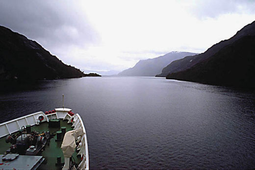
Beagle Channel
South of the Straight of Magellan is the
Beagle
Channel. This is a waterway that is surrounded by mountains and
seven separate glaciers that empty into it. The glaciers are named after
European countries like Italy, Romania, etc. The channel gets its name
from the ship Beagle that carried the naturalist Charles Darwin to South
America. |