|
Introduction
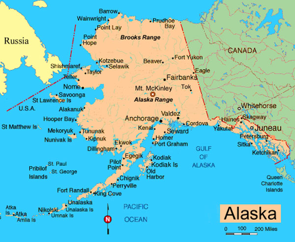
Alaska is a state of extremes. It is the largest of the 50
US states with about 1/5 the land area of the lower 48 combined. It
encompasses both the most easterly and westerly points in the United
Stated, has the sparsest population, highest mountain (Mt. McKinley or
Denali), most precipitation, largest glaciers and fjords, abundant fauna
and some of the most impressive geography anywhere in the USA.
Statistics
Origin of name
Corruption of Aleut word meaning "great land" or "that which the sea
breaks against"
Nickname
"Land of the Midnight Sun"
Motto
North to the Future
Area
570,375 sq miles (1,477,268 sq km)
Geographic center
60 mi. NW of Mt. McKinley
Diameter
East to west, 2,400 miles; north to south, 1,420 miles.
Easternmost and Westernmost points in the U.S.A.
The 180th meridian (halfway around the world from the prime meridian at
Greenwich, England) is the dividing line between the eastern and western
hemispheres. It passes through the Aleutian Islands of Alaska. Therefore,
Alaska has both the easternmost and westernmost spots in the country! The
easternmost is Pochnoi Point at 179d,46m East and the westernmost is
Amatignak Island at 179d,10m West.
Highest mountain
Mount McKinley (Denali) at 20,320 feet is the tallest mountain in the
North America. Alaska has 39 mountain ranges, containing 17 of the 20
highest peaks in the United States.
Longest river
Yukon, 1,875 miles in Alaska; 2,298 total. The Yukon River ranks third in
length of U.S. rivers, behind the Mississippi and Missouri rivers.
Largest island
Kodiak, in the Gulf of Alaska, 3,588 square miles. There are 1,800 named
islands in the state, 1,000 of which are located in Southeast Alaska.
Largest glacier
Bering Glacier complex, 2,250 square miles, which includes the Bagley Ice
field. Ice fields cover about 5 percent of the state, or 29,000 sq. mi.
Population
approximately 600,000
Capital
Juneau (population 31,000)
Largest city in population
Anchorage at 250,000 or ½ the population of the entire state
Largest city in area
Sitka, with 4,710 square miles
People
75% Caucasian, 15% Inuit and other indigenous groups, 4% black, 3.2% Asian
Major industries
Oil and gas (25% of US production), commercial fishing, mining, tourism
|
|
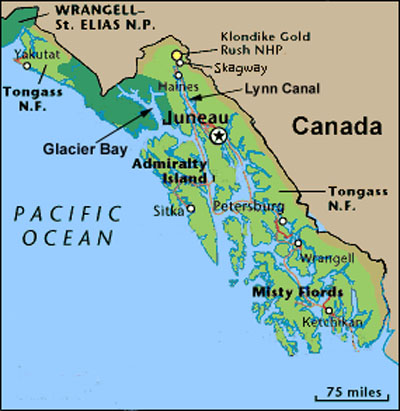
From a tourists point of view Alaska can be divided into
two regions -- the southeast panhandle and the Alaska mainland (primarily
its south-central region encompassing Anchorage, Kenai Peninsula, Denali
or Mt. McKinley and Fairbanks). There are also the Aleutian Islands and
far north which is usually not visited by the tourist. Alaska's panhandle
is a narrow strip of land about 400 miles long and about ten to 150 miles
wide extending to the southeast. It consists of a myriad of islands,
fjords, mountains and glaciers that is sandwiched between the Pacific
Ocean to the west and Canada to the east. The waterway in this archipelago
is Alaska's famous Inside Passage. Within its boundaries lie 1,000
islands, 15,000 miles of shoreline, America's largest national forest
(Tongass National Forest), thousands of coves and bays, 60 major glaciers,
15,000 bald eagles and 25,000 brown bears. Its first major attraction in
the south is the town of Ketchikan and nearby Misty Fjords National
Monument. Next is the quaint Russian town of Sitka. In the northern zone
of the Inside Passage is Alaska's capital Juneau and the Mendenhall
Glacier. Just to the north of Juneau is Glacier Bay and the Lynn Canal
with the town of Skagway at its northern terminus. Because of the
Panhandle's proximity to the sea, it has a relatively mild and wet
climate. Its mountains (Pacific Mountain System, part of the "Pacific Rim
of Fire") includes the Saint Elias Range and Wrangle Mountains. To the
north of the Panhandle in south-central Alaska this mountain system forms
the Chugach Mountains, Kenai Mountains (West to the Kenai Peninsula and
Kodiak Island), the Talkeetna Mountains, and the Alaska Range (north of
Anchorage, home to Mt McKinley). Two distinct lowland areas (the Copper
River Basin ending at Valdez and the Susitna-Cook Inlet lowland) are east
of Anchorage. The forested Copper River Basin lies between the Chugach and
Wrangell mountains. The Susitna-Cook Inlet extends north and east from
Anchorage, including the fertile farmland known as the Matanuska Valley.
The Central Uplands and Lowlands are rarely visited by the tourist. It is
found between the Alaska Range of the Pacific Mountain System in the south
and the Brooks Range of the Rocky Mountain System of Alaska in the north.
It's geography makes up the largest land area in Alaska. Bordered on the
east by Canada, the Central Uplands and Lowlands region extends westward
to include the Seward Peninsula and the Kuskokwim River area of
southwestern Alaska. The Central Upland and Lowlands area is marked by
low, rolling hills and swampy river valleys such as the those of the
Koyukuk, Kuskokwim, Tanana, and Yukon rivers.
North of the Central Uplands and Lowlands area is the Rocky Mountain
System of Alaska. This area is comprised of the Brooks Range and the
Brooks Range foothills. The Brooks Range rises to 9,000 feet above sea
level in the east with lower elevations in the west.
Extending southwest from the Alaska mainland is the Alaska Peninsula and
the Aleutian Islands and mountain range. The Aleutian Range extends 1,600
mile from Mount Spurr, across Cook Inlet from Anchorage, to Attu Island
near the Asian continent. Created in 1912 when Novarupta volcano erupted,
this range is home to the Valley of Ten Thousand Smokes, a land of
simmering volcanism. The Aleutians include 14 large islands and about 55
small islands. The largest islands are Unimak, Unalaska, and Umnak.
|
|
Misty Fjords National Monument
Misty Fjords gets its name from the deep sea-filled coastal
valleys or fjords and frequent mist and rain. Abundant moisture derived
from the sea and air masses lifting over the coastal mountains result in
considerable year-round precipitation (160 inches per year) and frequent
cloudiness. Consequently, rain during a visit is not uncommon regardless
of the time of year.
Created on December 1, 1978 by presidential proclamation, the Misty Fjords
National Monument encompasses 2,294,343 acres of the Tongass National
Forest in the southernmost part of Alaska's Panhandle. The monument
extends from Dixon Entrance to beyond the Unuk River and is only 22 miles
east of Ketchikan.
The Behm Canal, a section of the Inside Passage, leads to the heart of the
Monument. Picturesque areas such as Walker Cove and Rudyerd Bay are
surrounded by 3,000 foot rock walls rising above the ocean. An over-view
of the monument can be seen from the air by float-planes (e.g. the Beaver
single engine float-airplane) leaving from Ketchikan.
The Monument is an unspoiled coastal region with extraordinary geological
features including fiords, fresh water lakes, steep cliffs, active
glaciers and natural canals. The forests of Misty Fiords are primarily of
western hemlock and Sitka spruce, with scattered western red and Alaska
cedar. Between forest stands are openings called muskegs -- boggy areas
growing on deep peat and dominated by sphagnum mosses. These features
provide a fertile environment for birds and waterfowl.
The majestic landscape at Misty Fiords was created by thousands of years
of glaciation, volcanism and wave action. Bowl-shaped depressions at the
heads of the glacial valleys were enlarged into amphitheater-like basins
called cirques. In the northeast corner of the Monument, active glaciers
reside in upland plateaus and valleys. Some of the unique features on the
north end of the Monument were caused by the interaction of active
glaciers and volcanoes. Less than 150 years ago a lava flow partially
filled two of the U-shaped valleys of the Blue River. Trees lining the
Blue River valley drowned as the lake formed. Today, only their stumps
remain. In the Lava Fork valley, other trees carried along by the flood of
lava now lie on their sides, frozen in place within the flow. Another
example of volcanic activity is an island and pillar called New Eddystone
Rock. It resulted from a lava flow through fractures in the floor of Behm
Canal.
Misty Fiords National Monument has no roads, so access is by boat,
float-airplane or foot. The Park Service maintains and operates a system
of 16 cabins for public use. Cabins are located in a variety of forest
settings, providing users a choice of rustic settings ranging from open
ocean beaches to high alpine lakes.
Sitka
Sitka on Admiralty Island is sandwiched between the Pacific Ocean and Mt.
Edgecumbe -- an extinct volcano. Near the city's waterfront is St
Michael's Cathedral, a rebuilt replica of a 100-year-old Russian Orthodox
church. East of the city center, is the octagonal Sheldon Jackson Museum
with a collection of indigenous culture artefacts. A bit further east of
town is Sitka National Historical Park. The park features forest trails
and totem poles.
Juneau
Juneau, Alaska's capital, is a scenic city of 31,000. It is framed by the
snowcapped peaks of Mt Juneau and Mt Roberts, while the Gastineau Channel
provides access to its harbor. In the center of the city is the historical
district with St Nicholas Russian Orthodox Church and many buildings
dating back to the early 1900's. Just 13 miles from the capital is the
Mendenhall Glacier. Further north is Glacier Bay and the Lynn Canal.
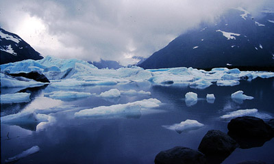
Glacier Bay National Park
Glacier Bay is an area of green forests, steep fjords, glaciers and
icebergs. Twelve tidewater glaciers formed in the Fairweather Range empty
into Y-shaped Glacier Bay, filling the sea with icebergs of all shapes,
sizes and shades of blue, white and green. The colors betray the ice
berg's nature or origin. White bergs hold many trapped air bubbles, blue
bergs are dense, greenish-blackish ones may have calved off glacier
bottoms and dark-striped brown oines carry morainal rock debre and ice. A
rich variety of humpback whales, harbor seals, porpoises, and sea otters
enhabit the bay. On land there are moose, mountain goats, brown and black
bears, wolves, and a variety of birds. The park is serviced by the
headquarters building and the small town of Gustavus.
A little about Glaciers:
Worldwide, glaciers and polar ice store more water than lakes, rivers,
groundwater, and the atmosphere combined. Ten percent of our world is
under ice today, equaling the percent being farmed. Alaska is four percent
ice, while Antarctica is 98%. Glaciers form because snowfall in the
mountains exceeds snowmelt. The Greenland and Antarctic ice caps are 2
miles thick. The glaciers of Glacier Bay are remnants of a general ice
advance -- the Little Ice Age -- that began about 4,000 years ago. The
Little Ice age reached its maximum extent here about 1750, when general
melting began. This in no way approached the extent of continental
glaciation during Pleistocene time.
Lynn Canal
The Lynn Canal is a natural 90 mile long inlet east of Glacier Bay and
north of Juneau. Its northern terminus is the town of Skagway. On either
side of the waterway are glaciers that pour out of the mountains and
descend toward the canal.
Skagway
Skagway is Alaska's northernmost stop on the Alaska Marine Highway's
Inside Passage. It is also the home of the Klondike Gold Rush National
Historic Park and stores and saloons of a bygone era. In its heyday
(1898), Skagway was the starting point for travel to the Klondike gold
fields. The trip started just outside Skagway where the 33-mile-long
Chilkoot Trail, accessible only on foot, ascended the coastal mountains.
It usually took three to five days if you survived the hazards. The trail
begins at the Taiya River bridge and travels over the Chilkoot Pass to
Lake Bennett. Today you can take this same journey from the comfort of a
narrow gauge scenic railway.
Alaska Mainland
Anchorage
Anchorage the largest city in Alaska houses 50% of the population of the
entire state. For the traveler, Anchorage is unavoidable, being the hub of
Alaska's road system and an international air junction. Many of the city's
attractions are within easy walking distance. The Anchorage Museum of
History & Art and the Heritage Library Museum both highlight the history
and culture of the state, the area's indigenous peoples and regional
artwork. On the west side of the city is Earthquake Park dedicated to the
the massive 9.2 magnitude 1964 earthquake.
Denali National Park
Two hundred-thirty miles north of Anchorage are the southern flanks of the
Alaska Range. Its showpiece (if it can be seen, which it usually isn't
because of clouds) is towering 20,320ft (6096m) Mt McKinley -- the highest
mountain in North America. Surrounding the mountain is Denali National
Park (native American for Mt. McKinley), our nation's premier subarctic
park. Encompassing 6 million acres, the park also has a rich variety of
wildlife including Tokalat grizzly bears, wolves, caribou, moose, and Dall
sheep.
Kenai Peninsula
The Kenai Peninsula, 43 miles south of Anchorage is a conglomerate of
mountains, fjords, icefields and glaciers. Kenai Fjords National Park
covers 587,000acres. It has an abundance of marine wildlife and glaciers,
including Harding Icefield. Towns of note in the peninsula include Homer
(a charming fishing village that is home to a number of artists and art
galleries), Seward and Soldotna.
|